Ayrshire Coastal Path – Fastest Known Time Fri. 30th October 2020
The day started early with a 3.10am alarm call, and a 3.45am pick up by Mark Canning who was going to provide driving support for the rest of the day.
The official start of the Ayrshire Coastal Path is a small carpark at Glenapp half way between Stranraer and Ballantrae.
I have a bit of history with the ACP as 8 years ago I had bravely (or rather stupidly) suggested I could run it over two days.
So with a 12hr run from Glenapp to Ayr, an overnight at home in Ayr, followed by a very painful 12hr stint saw me complete the 88mile route in 36hrs.
This time I was aiming to do the extended route which took in local landmarks Burns Cottage, Dundonald Castle, Kilwinning Abbey and Knock Hill which according to the official guide book is 100miles.
The longest I had run before was the 95mile West Highland Way Race in 2019 and I failed in my attempt to complete it in less than 24hrs https://www.blogger.com/u/1/blog/post/edit/4258126451196007456/2139774810999115412
After doing the Ring of Fire (see blog) I had planned to move on to doing the ACP, but then got a bit distracted by doing the reccies and support for Jack Scott’s successful FKT for the Southern Upland Way https://www.fionaoutdoors.co.uk/2020/11/runner-jack-scott-sets-new-southern-upland-way-record.html
A quick meet up with Mark Caldwell, who was going to run to Girvan (but possibly further) and had stayed overnight in his van. A quick photo at the official ACP board, and then a time check at 4.58am so we decided to hang on for the 2mins before heading off on the dot at 5am. 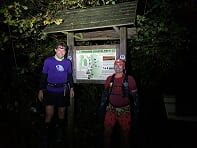 The first section of route is track followed by single track road, all the way to Ballantrae (9.5miles, 1hr 34mins) so the biggest challenge was keeping the pace down.
Along the stunning Ballantrae beach and then up over the hill to Lendalfoot – sadly this section is alongside the A77 but the verge is quite runnable and road was not too busy. North of Lendalfoot the route rises sharply, with the A77 hidden down below, and views out over Ailsa Craig.
The first section of route is track followed by single track road, all the way to Ballantrae (9.5miles, 1hr 34mins) so the biggest challenge was keeping the pace down.
Along the stunning Ballantrae beach and then up over the hill to Lendalfoot – sadly this section is alongside the A77 but the verge is quite runnable and road was not too busy. North of Lendalfoot the route rises sharply, with the A77 hidden down below, and views out over Ailsa Craig.


 The day had started cloudy and overcast but it was as if someone had swept the clouds away and we had clear views to the north to the rest of the route and out to Arran and Ailsa Craig. The strong SW tail wind stayed with us for much of the day. The route dropped back down to A77 soon enough, through fields of cattle so some nice, muddy, rutted and difficult terrain to cross and then back onto pavements for the run to Girvan harbour (22.5miles, 3hrs 55mins).
 The route to Turnberry goes from road to track, to rocky shore line, to boggy fields, back to rocky shore line and then finally a nice sandy beach as you approach the famous Turnberry lighthouse!
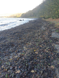
Across the famous golf course and then a bit more road down to Maidens where Mark called it a day after 31miles (5hrs 36mins). I was ahead of the planned schedule so there was no support runner, but I was expecting an easy section through Culzean Country park and then north along Croy shore. Only problem was, I was ahead of schedule for support runners but was also ahead of schedule for the tidal sections. So what should have been a sandy beach turned into long sections of seaweed covered rocks, rocky foreshore and generally tricky terrain!!
The route to Turnberry goes from road to track, to rocky shore line, to boggy fields, back to rocky shore line and then finally a nice sandy beach as you approach the famous Turnberry lighthouse!
Across the famous golf course and then a bit more road down to Maidens where Mark called it a day after 31miles (5hrs 36mins). I was ahead of the planned schedule so there was no support runner, but I was expecting an easy section through Culzean Country park and then north along Croy shore. Only problem was, I was ahead of schedule for support runners but was also ahead of schedule for the tidal sections. So what should have been a sandy beach turned into long sections of seaweed covered rocks, rocky foreshore and generally tricky terrain!!
 Just when I thought I was over the worst I realised I had to get round the small headland at the north of Croy shore. Knee deep, trying to step from boulder to boulder as the waves crashed in – I did briefly think about taking a few pictures or a video for the record - but then when a larger wave almost knocked me off one of the rocks and was close to soaking the tracker I decided just getting round safely was the best option!! Another bit of shoreline then some muddy fields before dropping into Dunure for a quick change of socks and an effort to empty the sand out of the shoes (38miles 6hrs 56mins).
Dunure to Bracken Bay is probably the hardest section of the route with a mix of soft shingle, muddy farmland, a section of rocky shore with some of the slippiest rocks you will find anyplace, and it is always a hard section whether the tide is high or not. for some bizzare reason there was a bike half way along this section!?
Just when I thought I was over the worst I realised I had to get round the small headland at the north of Croy shore. Knee deep, trying to step from boulder to boulder as the waves crashed in – I did briefly think about taking a few pictures or a video for the record - but then when a larger wave almost knocked me off one of the rocks and was close to soaking the tracker I decided just getting round safely was the best option!! Another bit of shoreline then some muddy fields before dropping into Dunure for a quick change of socks and an effort to empty the sand out of the shoes (38miles 6hrs 56mins).
Dunure to Bracken Bay is probably the hardest section of the route with a mix of soft shingle, muddy farmland, a section of rocky shore with some of the slippiest rocks you will find anyplace, and it is always a hard section whether the tide is high or not. for some bizzare reason there was a bike half way along this section!?
 Bobby Miller joined me at Bracken Bay and ended up running all the way to Troon.
 Just before Greenan Castle was the first detour of the day with a loop to take in Burns Cottage, (46miles, 8hrs 32mins) a quick photo stop and then back down to the shore, for the run through Ayr and Prestwick.


 I had a good turn out from friends from Rotary Club of Ayr, Bannatynes gym and my work as we progressed through Ayr and Prestwick. It added a bit of fun trying to work who was waiting with camera in hand or whether it was just a random dog walker!!
The various support runners had managed to catch up (or skive of work early) as I was now about 1.5hrs ahead of schedule so at one point going along the beach to Troon we were a group of 5 or 6. (57miles 10hrs 40mins).
I had a good turn out from friends from Rotary Club of Ayr, Bannatynes gym and my work as we progressed through Ayr and Prestwick. It added a bit of fun trying to work who was waiting with camera in hand or whether it was just a random dog walker!!
The various support runners had managed to catch up (or skive of work early) as I was now about 1.5hrs ahead of schedule so at one point going along the beach to Troon we were a group of 5 or 6. (57miles 10hrs 40mins).


 A trip round to Troon harbour and then the second detour of the day with an out and back over Smugglers trail to reach Dundonald Castle at about 60miles in. The highlight of the Smugglers trail was the fully grown horse grazing in a cottage front garden!! By this time the moon was up, the sun had set and the head torches had come out!


 Next section was following the cycle route round the back of Irvine papermill to eventually get to Irvine harbour– a new section for me so was glad we navigated with no major issues. (71.5miles, 14hrs and 5mins). The steady pace of the day started to decline and the walking became more frequent than the running. A big warm jacket was requested at Irvine when we met the support and had a lie down with the feet up to try and bring some life back to my tired body! Not sure it worked but it was quite pleasant looking up at the night sky and the full moon – I could have stayed for longer but had to keep pressing on.
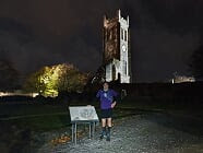
Back on the go again, still with Barry Duddy, who had joined me at Prestwick, with the next stop being the final detour with an out and back to Kilwinning Abbey, again following the cycle paths. Along the way we saw some head torches ahead, which then disappeared only to be surprised a few minutes later by Fran and Anna who had come to out to join us!! A missed turn led us onto the dual carriageway, but we could see the underpass so managed to go up the dual carriageway and then dropped down the steep embankment to get back on the route. Cycle paths in the dark can be confusing places but eventually we got to Kilwinning Abbey, a quick photo and then back the way we had come for a trip through what is affectionately known in Ayrshire as the three toon’s (Stevenston, Saltcoats and Ardrossan). It was 8 years since I had last done this section and I was a bit nervous about finding the route but a mix of beaches and promenade’s got us to Ardossan.
Next section was following the cycle route round the back of Irvine papermill to eventually get to Irvine harbour– a new section for me so was glad we navigated with no major issues. (71.5miles, 14hrs and 5mins). The steady pace of the day started to decline and the walking became more frequent than the running. A big warm jacket was requested at Irvine when we met the support and had a lie down with the feet up to try and bring some life back to my tired body! Not sure it worked but it was quite pleasant looking up at the night sky and the full moon – I could have stayed for longer but had to keep pressing on.
Back on the go again, still with Barry Duddy, who had joined me at Prestwick, with the next stop being the final detour with an out and back to Kilwinning Abbey, again following the cycle paths. Along the way we saw some head torches ahead, which then disappeared only to be surprised a few minutes later by Fran and Anna who had come to out to join us!! A missed turn led us onto the dual carriageway, but we could see the underpass so managed to go up the dual carriageway and then dropped down the steep embankment to get back on the route. Cycle paths in the dark can be confusing places but eventually we got to Kilwinning Abbey, a quick photo and then back the way we had come for a trip through what is affectionately known in Ayrshire as the three toon’s (Stevenston, Saltcoats and Ardrossan). It was 8 years since I had last done this section and I was a bit nervous about finding the route but a mix of beaches and promenade’s got us to Ardossan.

 (84miles, 17hrs 20mins). By this stage the pace had slowed and my left foot had been bothering me and the top of the toe on my right foot felt like it was getting a blister. Into the warm van to try and work out what was going on – eventually worked out it was a small stone which was stuck to the top of my toe and was rubbing against the shoe – once removed no more pain so a bit more lub on and a fresh sock on (just the one!!).
(Top tip – I have been using Songbird massage wax for all my running lub needs – works a treat. Other top tip is gatters – for all the sand and stones on this route I only had an issue with stones twice).
After a bit of food and two paracetamol it was time to go.
After a 30mile stint Barry was departing for home and Colin Anderson was waiting patiently to do the rest of the route. I asked Colin to take a jumper for me and then got out of van and had major “cold shakes”! I decided I should put the jumper on so back in the van, jumper on, jacket on, hat on and then still shaking set off to try and get some heat back in my body!
Within 10mins I was having to take the hat and jacket off again – whether it was just really cold on the headland, or it had got warmer I am not sure, but it was probably the lowest point of the day!
The route has been set up with walkers in mind so goes round headlands and various detours to see the sights, but on a dark autumn night some of the detours were slightly frustrating – but the route is the route. Across a bit of waste land where we managed to scare all the kids out drinking, and back alongside the main road north to Seamill. As we continue to head north the wind started picking up and there was a definite change in the air – rain and gales were due in at about 3am so it was fingers crossed it would stay off!. Just before Seamill it was back on the beach to get round the headland to Portencross. We were soon running out of beach (again) and having to clamber rocks and try and find a path on the sure. A bit of cursing and trying to work out how it could possibly be high tide again, before I realised it was about midnight so yes it was high tide again! Fortunately the rough sections were not too long and we were soon at the van again for a quick food and drink stop. 90miles, 19hrs and 8mins). A scone was forced on me as I had not been eating much and we set of for the most surreal part of the route – the section that goes passed Hunterson Port and Hunterston Nuclear Power station.
(84miles, 17hrs 20mins). By this stage the pace had slowed and my left foot had been bothering me and the top of the toe on my right foot felt like it was getting a blister. Into the warm van to try and work out what was going on – eventually worked out it was a small stone which was stuck to the top of my toe and was rubbing against the shoe – once removed no more pain so a bit more lub on and a fresh sock on (just the one!!).
(Top tip – I have been using Songbird massage wax for all my running lub needs – works a treat. Other top tip is gatters – for all the sand and stones on this route I only had an issue with stones twice).
After a bit of food and two paracetamol it was time to go.
After a 30mile stint Barry was departing for home and Colin Anderson was waiting patiently to do the rest of the route. I asked Colin to take a jumper for me and then got out of van and had major “cold shakes”! I decided I should put the jumper on so back in the van, jumper on, jacket on, hat on and then still shaking set off to try and get some heat back in my body!
Within 10mins I was having to take the hat and jacket off again – whether it was just really cold on the headland, or it had got warmer I am not sure, but it was probably the lowest point of the day!
The route has been set up with walkers in mind so goes round headlands and various detours to see the sights, but on a dark autumn night some of the detours were slightly frustrating – but the route is the route. Across a bit of waste land where we managed to scare all the kids out drinking, and back alongside the main road north to Seamill. As we continue to head north the wind started picking up and there was a definite change in the air – rain and gales were due in at about 3am so it was fingers crossed it would stay off!. Just before Seamill it was back on the beach to get round the headland to Portencross. We were soon running out of beach (again) and having to clamber rocks and try and find a path on the sure. A bit of cursing and trying to work out how it could possibly be high tide again, before I realised it was about midnight so yes it was high tide again! Fortunately the rough sections were not too long and we were soon at the van again for a quick food and drink stop. 90miles, 19hrs and 8mins). A scone was forced on me as I had not been eating much and we set of for the most surreal part of the route – the section that goes passed Hunterson Port and Hunterston Nuclear Power station.
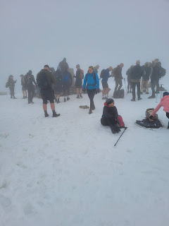
 Half expecting to be stopped by security at any moment there was definitely a feeling that we were being watched. Once passed the highlight was the owl out hunting and then the noise from a flock of geese taking off – we never saw them but we certainly heard them (I’m told they are known to take off roughly an hour before high tide – I have no idea whether this is true or not!). Back on the cycle paths to Fairlie – after quite a long spell of mainly walking I had decided that the walk / run strategy should come out to play. Colin had been quietly working out the pace and the times and had worked out sub 24hrs was still possible but if the walking continued then it may slip away. Again the section through Fairlie to Largs had been done 8 years ago so there was a bit of, I can’t remember where I was going and then remembering sections again. Along the cycle path passed the marinas, by this time the wind was howling in the yacht rigging, and the weather holding off before going up and over Knock Hill was looking less and less likely. The run / walk strategy was working well, sometimes aided by the increasingly strong tail wind which sometimes turned into a head wind which gave another excuse for a walk. A deserted Largs prom with the colourful lights and then a quick meet up with the support van again. (99miles, 21hrs and 23mins) With the same van all day I had got quite adept at spotting Mark and his van from afar, and half way round the bay I spotted the lights. Just as we approached another car turned up and Susie Hubbard who had run earlier in the day, had dragged her poor husband Raymond out of his bed to get a lift to come back and join us. Very quickly we grabbed a drink and some blueberries we set off. We did meant to grab my poles which I thought would be useful for Knockhill, but we all forgot, but fortunately we did remember my charge cable for my watch! Just as we left the rain started and never let up till the finish. (100miles, 21hrs 37mins). A bit of road and then track and then a really muddy track to the start of Knockhill. We then had a slight navigational error when we missed the path and had to backtrack about 50m to pick up the path. The path up Knockhill was ankle deep bog, and if you were unlucky knee deep bog, and the wind and rain was getting progressively worse, so it was a matter of getting to the top, quick photo and then drop back down as quickly as possible! I had been using my watch on the way up to check the route and was a bit dismayed on the way down to see a blank screen.
 Normally it gives a couple of warnings but I think in the wind and rain I had missed them. Rather than getting off the hill quickly we were standing around waiting to get the watch restarted to record the route – eventually it started and we could head back down the muddy descent to the road. It only missed probably a 200m section and we had a photo at the end of that section so it was probably the best place it could have happened.
Colin and I had done an out and back on the route last Sat so the route was quite familiar – a few up and downs, back down to the main road and then a steep climb away from the road again and then more undulations. I knew the last mile or so was downhill, and the run / walk strategy was still going well. The last few miles passed relatively quickly and we were soon on the last downhill to the finish post.(106.83miles, 5,912ft of elevation, in 23hrs 38mins and 40s) https://fastestknowntime.com/route/ayrshire-coastal-path
Normally it gives a couple of warnings but I think in the wind and rain I had missed them. Rather than getting off the hill quickly we were standing around waiting to get the watch restarted to record the route – eventually it started and we could head back down the muddy descent to the road. It only missed probably a 200m section and we had a photo at the end of that section so it was probably the best place it could have happened.
Colin and I had done an out and back on the route last Sat so the route was quite familiar – a few up and downs, back down to the main road and then a steep climb away from the road again and then more undulations. I knew the last mile or so was downhill, and the run / walk strategy was still going well. The last few miles passed relatively quickly and we were soon on the last downhill to the finish post.(106.83miles, 5,912ft of elevation, in 23hrs 38mins and 40s) https://fastestknowntime.com/route/ayrshire-coastal-path
 The finish video Mark Canning took sums up the effort that everyone puts into these mad challenges. Mark had put in a massive 28hr support shift, Colin and Susie had come out to run till 4am and Raymond had come out to drive Susie.
The priority was to try and get warm and dry again but Mark had left his van at the top of the hill, so we agreed to walk down the hill to the main round while he brought the van round.
People often ask if I feel elated at the end of long races, but often it is just relief that I could stop moving!
Huge thanks to Mark Canning for the excellent vehicle support and full credits for all the cracking photos! Big thank you to all the runners who came out to run – I have great memories of various runners appearing out of nowhere and making the effort to join in.
Big thanks to everyone else who came out to support – you all know who you are!!
Route Distance
The official guide states the route is 100miles, however on plotting the route it came in at 104miles, which as you know when you do the twists and turns of small paths often ends up a mile or two further. My mistake with the tides meant I ran much of the route at the high water mark increasing the distance further.
I think you can probably follow the route in full by doing around 105miles!
Gear and Support
It is an easy route to support as there are very few sections where you are far from the road.
The south section is certainly the tougher terrain and shoe choice is difficult with the variation from sand, stones, mud, bog and pavement. I used Brooks Cascadia for the whole route which worked very well.
I did have La Sportiva trail shoes and Brooks road shoes with me but it is tricky to know where you would change, so I never used them.
Rotary Club of Ayr
Thanks to the https://rotaryclubofayr.org/ for putting together the Ayrshire Coastal Path. First opened in 2008, and put together with less than £70,000 of funding, and lots of hard work from Rotarians and volunteers.
Responsibility for the route has now transferred to https://ayrshirecoastalpath.org/ but still relies on a hardy bunch of volunteers. Ever time you go on the route there is always a new gate, a new bridge, or a newly cut track as the team work to make the path better every year.
To help support their work you can donate on their website or even better buy the official guide https://ayrshirecoastalpath.org/guidebook/
The author Jimmy Begg continues to donate any proceeds from the guide book to charity.
The management committee have set a protocol for any FKT attempts, so if you do plan to take on the route please contact them through their website!
The finish video Mark Canning took sums up the effort that everyone puts into these mad challenges. Mark had put in a massive 28hr support shift, Colin and Susie had come out to run till 4am and Raymond had come out to drive Susie.
The priority was to try and get warm and dry again but Mark had left his van at the top of the hill, so we agreed to walk down the hill to the main round while he brought the van round.
People often ask if I feel elated at the end of long races, but often it is just relief that I could stop moving!
Huge thanks to Mark Canning for the excellent vehicle support and full credits for all the cracking photos! Big thank you to all the runners who came out to run – I have great memories of various runners appearing out of nowhere and making the effort to join in.
Big thanks to everyone else who came out to support – you all know who you are!!
Route Distance
The official guide states the route is 100miles, however on plotting the route it came in at 104miles, which as you know when you do the twists and turns of small paths often ends up a mile or two further. My mistake with the tides meant I ran much of the route at the high water mark increasing the distance further.
I think you can probably follow the route in full by doing around 105miles!
Gear and Support
It is an easy route to support as there are very few sections where you are far from the road.
The south section is certainly the tougher terrain and shoe choice is difficult with the variation from sand, stones, mud, bog and pavement. I used Brooks Cascadia for the whole route which worked very well.
I did have La Sportiva trail shoes and Brooks road shoes with me but it is tricky to know where you would change, so I never used them.
Rotary Club of Ayr
Thanks to the https://rotaryclubofayr.org/ for putting together the Ayrshire Coastal Path. First opened in 2008, and put together with less than £70,000 of funding, and lots of hard work from Rotarians and volunteers.
Responsibility for the route has now transferred to https://ayrshirecoastalpath.org/ but still relies on a hardy bunch of volunteers. Ever time you go on the route there is always a new gate, a new bridge, or a newly cut track as the team work to make the path better every year.
To help support their work you can donate on their website or even better buy the official guide https://ayrshirecoastalpath.org/guidebook/
The author Jimmy Begg continues to donate any proceeds from the guide book to charity.
The management committee have set a protocol for any FKT attempts, so if you do plan to take on the route please contact them through their website!


Comments
Post a Comment